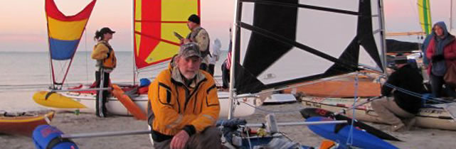
ABOUT US: Events and Specials
CELEBRATE WITH THE NEW OWNER OF
BALOGH SAIL DESIGNS (BSD) - DAVID VALVERDE
TWENTIETH ANNUAL, FALL 2010
BORN TO RAISE SAIL
KAYAK AND CANOE SAILORS GATHERING
Download a pdf file with all information
DATES: OCTOBER 1,2,3
PLACE: CEDAR ISLAND, NORTH CAROLINA, DRIFTWOOD MOTEL AND CAMPGROUND
/
HIGHWAY 12 AT CEDAR ISLAND FERRY LANDING
WHO SHOULD ATTEND: KAYAK AND CANOE SAILORS AND ANYONE WHO SAILS IN SMALL, FOLDABLE OR INFLATABLE, PORTABLE SAILBOATS OR SOMEONE WHO IS INTERESTED IN BUYING A SAILING KAYAK OR CANOE.
ACTIVITIES: SOCIALIZING, EXCHANGING IDEAS AND RIGGING/SAILING TECHNIQUES. THIS IS A GATHERING FOR PEOPLE WITH COMMON INTERESTS.
An “all you can eat” buffet seafood dinner is planned for Sat. night. Tickets can be purchased at the gathering.
Please let us know if you plan to come and how many people you expect to be attending the Saturday buffet.
FOR MORE INFORMATION OR to TELL US YOU ARE COMING, PLEASE CONTACT:
DAVID VALVERDE
(718) 548 1188
440 E 78 St #2C, NEW YORK, NY 10075
davev@baloghsaildesigns.com
SOME INFORMATION TO HELP YOU PLAN:
Weather permitting we will be sailing in Pamlico Sound, Cedar Island Bay or Core Sound.
A statistical mean Cedar Island October day is about 72 degrees high and 59 degrees low.
The water temperature is about 70 degrees. The wind is North to Northeast at 11 to 13 m.p.h. The relative humidity is 55% to 85% with cloud cover.
Although this is a statistical probability, we are looking at October, and there is the probability of increasing cold fronts. Bring foul-weather gear. October fronts can also bring winds of 15 to 30 m.p.h. or more - hard-core kayak sailing weather. Bring plenty of floatation and safety gear and small or reefable sails. Expect winds from light to gale force. THE RULE IS: COME PREPARED FOR ANYTHING!
The gathering will be headquartered at the Driftwood Motel and Campground. Accommodations are personal. Camping is available.
The gathering is during the local off season so there should not be any problems with camping space, although it is a good idea to reserve motel rooms early just to be safe.
The motel has a restaurant serving breakfast and dinner. There is a small grocery and convenience store 1/2 mile away with food and beverages and a snack bar.
Even if you stay in the hotel, a cooler of food is a good idea. Last chances for chain supermarkets are Morehead City or Beaufort. If you are particular about the flavor of drinking water, you may wish to bring your own.
The previous years gathering brought friendly, interesting people from Colorado, England, Illinois, Maine, Maryland, New York, North Carolina, Texas, Vermont, Virginia and Wisconsin.
Boats ranged from canoes to hardshell, inflatable and folding kayaks. This has certainly become the sailing kayak/canoe event of the season. Come to the gathering and meet some of the most interesting and friendly people in the sport of kayak and canoe sailing.
DIRECTIONS:
For those with foldable boats who wish to fly, the closest airport is at New Bern, NC. There are rental cars available. The drive to Cedar Island from New Bern is about 1.5 hours.
To drive there from the N.E. or the N.Y. city area, you can go South from NY City on the Jersey Turnpike to I-95 South through or past Philadelphia, Baltimore, DC and Richmond into N.C. Or you can take a rout down through Delaware on 13, down Maryland ‘s eastern shore to the Chesapeake Bay Bridge Tunnel, past Northfolk to 17 South.
17 South will take you to New Bern, where you will take 70 east. The I-95 route is longer in miles, but depending on the traffic in the cities and your driving, it can be 1-2 hours faster in time. The Delaware route is shorter in miles and more scenic, but is mostly 2 and 4 lane highway with traffic lights, etc. Call for more info.
Coming from the North on I-95, proceed south until you come to N.C. highway 70 East at exit 97 or 95. You can cut of few miles by getting off at Wilson and taking 58 to Kinston or getting off at 117 to Goldsboro, but these are 2 lanes and you take your chances on farm traffic. I have had good luck on 58.
Coming from N. or S. on I-95, get off onto Hwy. 70 East toward Goldsboro. As you are coming into Goldsboro, you will have to make a cloverleaf type right turn (you turn right but the clover leaf takes you around to the right about 2700 and you really end up in the final analysis turning to the left or east). At an overpass stay on highway 70. Whenever you are given a choice at towns between bypass and business routes, I’d go bypass. Keep going east on Hwy 70 toward Kinston. Take the 70 bypass around Kinston. The same procedure for New Bern.
When you come to Havelock, start to look for hwy 101, it is in the middle of Havelock and only goes left. There are 2 left turn lanes and I prefer to stay in the right one. This is because the entrance to the Cherry Point Marine Air Station is just around the corner, and you want to get in the right lane on Hwy 101 to avoid getting into the entrance lanes for Cherry Point. Proceed on Hwy 101 for about 17 mi until you cross the high rise bridge across Core Creek. From here on out you will start to see signs to the Cedar Island/Ocracoke Ferry (CIOF). We are on Cedar Island, so that will help. (If you turn on to 101at Havelock, you will bypass Morehead City and Beaufort. If you wish to go to these places for shopping, restaurants or sightseeing stay on Hwy 70. Approximately 1+mile past Core Creek Bridge, turn left (only choice) on Laurel Road (CIOF sign). Follow Laurel road until “T” intersects, about 2.2 miles, and turn right. About 2.6 mi later you will come to a traffic light, a ‘TeePee’ Store and a CIOF sign where you will take a left turn back onto Hwy 70 East, it is about 30 mi from here to Cedar Island. You will need to follow Hwy 70 for about 15 or so miles and you will make 2 left turns at stop signs. One turn is at Smyrna and one at Davis. After you go past the community of Stacy, you will cross a High Rise Bridge. (Davis to high rise bridge 8? miles). At the bottom of the bridge will be a right turn to stay on Hwy 70. DON’T TURN RIGHT. Many people chose to ignore me and turn right anyway. A right turn will take you a few miles out of your way and bring you back to the same place anyway. Just after that turn the same road you are on changes its name to Hwy 12. Follow it. The road will come out of the trees onto the marsh and come to another high rise bridge. Abandon hope all ye who cross this bridge as you will back in time at least 20 years and into the territory of the SaILS Angels. Be sure to bring you colors. Cross the bridge if you dare and proceed across the marsh until you enter the trees again. Proceed up the island to the end of Hwy 12 where you will find the ferry landing, and the Driftwood Motel and Camp Ground. If you have any questions about the instructions, please feel free to contact us. Looking forward to seeing you at the gathering. Have a safe trip.
The Sails Angels
davev@baloghsaildesigns.com
END OF SUMMER SALE:
(until Sept. 30, 2010)
ATLANTIS 12
BSD BOSS™
32' BATWING™
$2150
Available NOW - Complete, BSD Boss™ Batwing™/Feel Free Kayaks DEMO PACKAGES
(click for available packages)
******************************
FREE SHIPPING on an order of 3 OR MORE BSD T-SHIRTS


UNISEX BSD T-SHIRTS
used for urban sportswear and
weekend getaways
No seams on sides,
preshrunk 100% cotton
colors: black, red (now available)
$19.99 regular price
Sizes: S M L XL
NOW AVAILABLE - RED T-SHIRTS! 
******************************
